 S u r i n a m e
 S u r i n a m e
Suriname is a small country in South America, located on the Northeastern coast. It is the middle of the three Guyanas. The capital is Paramaribo, which means "city of flowers". In it's early days, Paramaribo was called Parmurbo. The name Suriname is derived from the Surinen, an Indian tribe that lived in the area that nowadays is called Guyana and Suriname. Click here to see Suriname on the map of the world.
Suriname became independent on Tuesday November 25, 1975. Before that day Suriname was a colony of the Netherlands. As a result of that situation, Dutch is the official language in Suriname. In case you didn't know, dutch is the language that is spoken in the Netherlands.
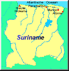
Suriname has a small population. There are only 487,000 people living there. Most of them live in the capital Paramaribo. Suriname has a surface area of 163,820 square kilometres, that would be like 63,775 square miles. Surinam borders on Brazil in the south. West of Suriname lies a country called Guyana, which was a colony of Great Brittain. East of Suriname is French Guyana, which still is a colony of France. To the north of Suriname is the big Atlantic Ocean. Suriname lies on the northern hemisphere of our globe. Paramaribo lies 6 degrees North Latitude and 55 degrees West Longitude on a river called the Suriname. The population of Suriname consists of people with different kinds of backgrounds. The native Americans, the Indians, are still living there. There are black persons living there, Hindustans, Chinese, Javanese, Jews, Dutchmen and other Europeans, Libians and many other nationalities that I cannot mention here. It is good to see, that there are many kinds of people living in that country and that they are getting along. Ofcourse all of these people have different religions. There are many Christians, Muslims and Hindu's in Suriname. And there are other small religions that are not mentioned here. All those different people with there religions have learned to get along with each other. In Paramaribo there are a Christian church and Jewish synagogue right next to each other and they never got into trouble with each other. All those different people also speak different languages, but almost everyone in Suriname can speak at least a little bit dutch. There is a Surinamese language too. It is called Sranang Tongo. That language is a result of mixing different languages with each other. There are Dutch, English, Spanish, French and Portuguese words in the Suriname language. There are also words taken out off African language, brought by the black people, who were slaves taken out of Africa. Most slaves were taken of the area, which is called Ghana nowadays.
The Dutch influence still can be noticed in Suriname. Just like in other former colonies, Suriname also has villages with Dutch names, like Nieuw Amsterdam (New Amsterdam), Utrecht, Groningen, Alkmaar, Wageningen, Dordrecht, Uitkijk, Domburg, Boxtel, Berg en dal, Tafelberg, Waterloo, Waterland, Gelderland, Katwijk, Haarlem, Voorburg, Willemsburg, Bergen op Zoom, Bernharddorp, Bloemendaal (A neighbourhood in Paramaribo), Fort Zeelandia (a former fort in Paramaribo, nowadays a museum), Zanderij (Where the international airport Johan A. Pengel is located, about 45 kilometres or 28 miles south of Paramaribo) and Lelydorp, called after the Dutch engineer Cornelis Lely, responsible of great reclaim projects in the Netherlands like the Flevoland Polder and the Afsluitdijk, a dike which enclosed the Zuiderzee, nowadays the IJsselmeer.
If you walk through the streets of Paramaribo you will see typical dutch names like the Gravenstraat, Heiligenweg, Jodenbreestraat, Maagdenstraat, Klipstenenstraat, Keizerstraat, Heerenstraat, Kerkplein, Domineestraat, Soldatenstraat, Weidestraat, Zwartehovenbrugstraat, Van't Hogerhuysstraat, Rust en Vredestraat, Wagenwegstraat, Steenbakkerijstraat, Watermolenstraat, Van Sommelsdijkstraat, Prins Hendrikstraat, Wilhelminastraat, Julianastraat, Regentessetraat, Oranjelaan, Kleine Waterstraat, Burenstraat, Stoelmanstraat, Onafhankelijkheidsplein (Square of independence) and last but certainly not least the Waterkant on the bank of the Suriname river in Paramaribo.
The only thing that is remarkable is that they drive on the left side of the road in Suriname, while the traffic in the Netherlands is on the right side of the road..... Well.... If you know something about the Suriname history, you can find a logical explanation for this. Most of the time Suriname was owned by the Dutch, but other times the Brittish had all the power in Suriname. Most people know that they drive on the left side of the road in the United Kingdom, so the Brittish influence made that nowadays they still drive on the left side in Suriname. During the time when the Brittish ruled Suriname one made a start with creating the infrastructure and building roads. After the Brittish left the country, their influence stayed, because it would be too hard to change the way the traffic acts and that's why nowadays they still drive on the left side of the road in the Republic of Suriname, just like in other countries with Brittish influence.
Suriname is not a rich country. Since January 1st, 2004 the monetary unit of Suriname is the Surinamese Dollar. Before that date the monetary unit was the Surinamese Guilder. Because of the bad economic situation in Suriname, the Surinamish Guilder was not worth much. Because of that the decision was made to introduce the Surinamese dollar as the new Surinamese monetary unit. Better days will come for Suriname. Suriname has a lot of potention and in the future, Suriname will use it's capacities.
Most of the people in Suriname live in the capital Paramaribo. The north side of the country is the part with the best infrastructure. All the cities are located in the north of the country. Some little settlements are in the other parts of the country. When Suriname just was discovered and owned by the Dutch, the country was much smaller. To get an idea: Only the first 100 kilometres starting from the coast of the country belonged to Suriname. The other part was owned by the Portuguese and would belong to Brazil, but the Portuguese gave the ground north of the 'Guyana mountains' away to the Guyana countries. That's why Guyana, the former English Guyana, Suriname, the former Dutch Guyana, and French Guyana are the size they are nowadays.
Here is a list of the 10 Provinces in Suriname with their capitals:
| Province / District | Capital | ||
| 1. | Paramaribo | Paramaribo | |
| 2. | Wanica | Lelydorp | |
| 3. | Commewijne | Nieuw Amsterdam | |
| 4. | Marowijne | Albina | |
| 5. | Para | Onverwacht | |
| 6. | Brokopondo | Brokopondo | |
| 7. | Saramacca | Groningen | |
| 8. | Coronie | Totness | |
| 9. | Nickerie | Nieuw Nickerie | |
| 10. | Sipaliwini | Sipaliwini |
America was discovered on wednesday october 12 1492 by Christophoro Columbus. By that time some people still had the opinion that the world was flat. The other people knew the world had to be round, because of they had noticed the way ships gradually appear or disappear on the horizon. Columbus was one of the people who did believe that the world was round, but he thought the world was smaller than it actually is. Everybody told him that the world was bigger than what he thought it was. He wanted to prove that he was right by discovering a new route to India. By that time the only way to go to India from Europe was by going to South Africa and than continue the journey to India by going eastward. This was a circulous route. Columbus was born in Portugal. But the Portugese didn't believe him. So later on the Spanish offered him the chance to make his journey. As we know now they were lucky that they did that, because nowadays whole Latin America is under Spanish influence. When Columbus discovered America, he thought he was in India. So he called the people who lived there Indians. This is the reason that this area was called the West-Indies later on.
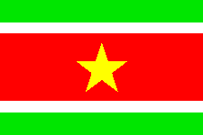
 In 1954 Suriname was recognized by the Netherlands as Overseas Territory in stead of a Dutch colony. In that year the flag next to this text was introduced as the Suriname flag. This flag was used until november 25 1975, the day when Suriname became an independent republic. On my page about the Suriname Arm, Anthem and Flag there is an explanation of the symbolism of this flag.
Suriname is a country of which there is a lot to tell about. Obviously it is impossible to write everything about this country on this site, but an effort was made to made this site informative regarding general subjects, which have to do with the Republic of Suriname. To give a better overview of the available information it was divided into several sections.
By the way: In Surinam we call our country Sranan. Nice to know, huh? I thought so.....
Suggestions? Send an electronic mail to: pajtroon@dds.nl.
This page: Copyright © 2000 - 2019 Peter A. J. Troon